Complete table of traffic signs with explanations for 2018. Detailed comments on traffic signs for 2018.
Warning signs


Warning road signs in this group inform motorists about a dangerous section of the road that requires the driver to take action. In most cases, warning signs are a triangle with a red border.
Explanation of the 2018 Warning Signs
1.1 Railway crossing with barrier
They are installed in populated areas 50-100 m, outside populated areas 150-300 m before the start of the dangerous area. Approaching a railway crossing equipped with a barrier. The driver is obliged to reduce speed and assess the situation. This sign is duplicated only outside the populated area; the second sign is installed at a distance of at least 50 m before the start of the dangerous section.
1.2 Railway crossing without a barrier
They are installed in populated areas 50-100 m, outside populated areas 150-300 m before the start of the dangerous area. Approaching a railway crossing that is not equipped with a barrier. The driver is obliged to reduce speed and assess the situation. This sign is duplicated only outside the populated area; the second sign is installed at a distance of at least 50 m before the start of the dangerous section.
1.3.1 Single track railway
Installed directly in front of railway crossings without barriers. Approaching a single-track railway crossing that is not equipped with a barrier. Drivers are warned about the presence of a single-track railroad crossing that is not equipped with a barrier. The driver is obliged to reduce speed and assess the situation.
1.3.2 Multi-track railway
Installed directly in front of railway crossings without barriers. Approaching a multi-track railway crossing that is not equipped with a barrier. Drivers are warned about the presence of a railway crossing with several tracks that is not equipped with a barrier. The driver is obliged to reduce speed and assess the situation.
1.4.1 - 1.4.6 Approaching a railway crossing
Additional warning about approaching a railway crossing outside populated areas. This sign can be installed simultaneously on the right and left sides of the road (the inclined red stripe is directed towards the roadway). Signs are installed:
- 1.4.1, 1.4.4 - for 150 - 300 meters
- 1.4.2, 1.4.5 - for 100 - 200 meters
- 1.4.3, 1.4.6 - for 50 - 100 meters
1.5 Intersection with tram line
They are installed in populated areas 50-100 m, outside populated areas 150-300 m before the start of the dangerous area. Warns of approaching an intersection with tram tracks outside the intersection or before the intersection when visibility of the tram tracks is limited (less than 50 m). When approaching such an intersection, the driver must be especially careful, since in most cases the tram has the right of way, that is, the driver must give way to the tram. The driver is obliged to reduce speed and assess the situation.
1.6 Intersection of equivalent roads
They are installed in populated areas 50-100 m, outside populated areas 150-300 m before the start of the dangerous area. Can be equipped with a pedestrian crossing. You must give way to any vehicles approaching from the right and to pedestrians. The driver is obliged to reduce speed and assess the situation.
1.7 Roundabout
They are installed in populated areas 50-100 m, outside populated areas 150-300 m before the start of the dangerous area. Warns when approaching a roundabout. The movement in the ring goes counterclockwise. The driver is advised to reduce speed and assess the situation.
1.8 Traffic light regulation
They are installed in populated areas 50-100 m, outside populated areas 150-300 m before the start of the dangerous area. Warns about an intersection, pedestrian crossing or other section of the road where traffic is regulated by a traffic light. The driver is advised to reduce speed and assess the situation.
1.9 Drawbridge
They are installed in populated areas 50-100 m, outside populated areas 150-300 m before the start of the dangerous area. Drawbridge or ferry crossing. When entering the ferry, you must follow the instructions of the ferry officer on duty, allowing vehicles leaving the ferry to pass. The driver is advised to reduce speed and assess the situation. This sign is duplicated only outside the populated area; the second sign is installed at a distance of at least 50 m before the start of the dangerous section.
1.10 Departure to the embankment
They are installed in populated areas 50-100 m, outside populated areas 150-300 m before the start of the dangerous area. Departure to the embankment or shore. They warn drivers about going to an embankment, river bank, or lake, where there is a danger of the vehicle sliding into the water. The driver is advised to reduce speed and assess the situation. This sign is duplicated only outside the populated area; the second sign is installed at a distance of at least 50 m before the start of the dangerous section.
1.11.1, 1.11.2 Dangerous turn
They are installed in populated areas 50-100 m, outside populated areas 150-300 m before the start of the dangerous area. Curving road with a small radius or with limited visibility to the right. The driver must remember that in such areas such maneuvers as overtaking, turning around and reversing are prohibited. The driver is obliged to reduce speed and assess the situation.
1.12.1, 1.12.2 Dangerous turns
They are installed in populated areas 50-100 m, outside populated areas 150-300 m before the start of the dangerous area. They warn you about approaching a section of road with two dangerous turns following each other. The driver must remember that in such areas such maneuvers as overtaking, turning around and reversing are prohibited. The driver is obliged to reduce speed and assess the situation.
1.13 Steep descent
1.14 Steep climb
The numbers indicate the slope in hundredths. Features: in case of difficult oncoming traffic, the driver moving downhill must give way.
1.15 Slippery road
A section of road with increased slipperiness of the roadway. The driver is required to reduce speed.
1.16 Rough Road
A section of road that has unevenness on the roadway (undulations, potholes, uneven junctions with bridges, etc.).
1.17 Artificial hump
Warns of artificial bumps on the road.
1.18 Gravel release
A section of road where gravel, crushed stone and the like can be thrown out from under the wheels of vehicles.
1.19 Dangerous roadside
A section of road where pulling off to the side of the road is dangerous.
1.20.1 - 1.20.3 Narrowing of the road
- 1.20.1 Narrowing of the road on both sides.
- 1.20.2 Narrowing of the road on the right side.
- 1.20.3 Narrowing of the road on the left side.
1.21 Two-way traffic
The beginning of a section of road (roadway) with oncoming traffic.
1.22 Pedestrian crossing
Approaching an unregulated pedestrian crossing.
1.23 Children
A section of road near a child care facility (school, health camp, etc.), on the roadway of which children may appear.
1.24 Intersection with a bicycle path or pedestrian path
Warns about crossing a bicycle or pedestrian path.
1.25 Road works
Warns of road works nearby.
1.26 Cattle drive
Warns that livestock may be driven nearby.
1.27 Wild animals
They warn that wild animals may run onto the road.
1.28 Falling stones
A section of road where avalanches, landslides, and falling rocks are possible.
1.29 Side wind
Warns of strong cross winds. It is necessary to reduce your speed and stay as close as possible to the center of the lane you occupy, so that in case of a rush you do not end up on the side of the road or in the oncoming lane.
1.30 Low-flying aircraft
Warns of low-flying aircraft.
1.31 Tunnel
A tunnel in which there is no artificial lighting, or a tunnel in which the visibility of the entrance portal is limited. Before entering a tunnel, you must turn on the low or high beam headlights (so that if the lighting in the tunnel is turned off, you will not find yourself in a moving car in a dark space).
1.32 Congestion
A section of road where there is a traffic jam.
1.33 Other hazards
A section of road that contains hazards that are not indicated by other warning signs.
1.34.1, 1.34.2 Direction of rotation
1.34.3 Direction of rotation
Direction of movement on a curved road of small radius with limited visibility. Direction to bypass the road section being repaired.
Priority signs


Priority signs indicate the order of passage of a particular section of the road/intersection: which of the vehicle drivers can pass first, and who must pass. In most cases, priority signs are made in a triangle (adjacent road, give way), but there are also diamond-shaped, hexagonal (STOP), round (advantage to oncoming traffic) and square (advantage to oncoming traffic).
Explanations for the 2018 Priority Signs
2.1 Main road
A road on which the driver has priority at intersections. Cancelled by 2.2
2.2 End of main road
Cancels sign 2.1
2.3.1 Intersection with a minor road
Warns about the proximity of intersections with secondary roads on the right and left simultaneously
2.3.2 - 2.3.7 Junction of a secondary road
- 2.3.2 Warns about the proximity of a secondary road on the right
- 2.3.3 Warns about the proximity of a secondary road on the left
- 2.3.4 Warns about the proximity of a secondary road on the right
- 2.3.5 Warns about the proximity of a secondary road on the left
- 2.3.6 Warns about the proximity of a secondary road on the right
- 2.3.7 Warns about the proximity of a secondary road on the left
2.4 Give way
The driver must give way to vehicles moving on the road being crossed, and, if there is a sign 8.13, on the main road.
2.5 Driving without stopping is prohibited
It is prohibited to drive without stopping in front of the stop line, and if there is none, in front of the edge of the intersecting roadway. The driver must give way to vehicles moving along the intersection, and if there is a sign 8.13 - along the main road. Sign 2.5 can be installed in front of a railway crossing or quarantine post. In these cases, the driver must stop in front of the stop line, and if there is no stop line, in front of the sign.
2.6 Advantage of oncoming traffic
It is prohibited to enter a narrow section of road if this may impede oncoming traffic. The driver must give way to oncoming vehicles located in a narrow area or the opposite entrance to it. If a motorcycle without a sidecar is moving towards you, and it is possible to pass it in a narrow area, then you can continue driving.
2.7 Advantage over oncoming traffic
The driver has the right to pass the narrow section of the road first.
Prohibition signs


Prohibiting traffic signs determine restrictions on the movement of certain vehicles in certain areas/traffic conditions. Almost all of them are made in a round shape with a red border (except for those that remove movement restrictions).
Explanations for Prohibition Signs 2018
3.1 Entry prohibited
Entry of all vehicles in this direction is prohibited. This road sign can be seen on one-way roads, at the entrance opposite the direction of travel. Valid until the first intersection.
3.2 No movement
All vehicles are prohibited. The exception is public transport vehicles and cars that transport disabled people. Valid until the first intersection.
3.3 Motor vehicles are prohibited
The movement of motor vehicles is prohibited. Valid until the first intersection.
3.4 Truck traffic is prohibited
It is prohibited to drive trucks with a maximum permitted weight indicated on the sign (if there is no weight on the sign - no more than 3.5 tons). Valid until the first intersection.
3.5 Motorcycles are prohibited
The movement of two-wheeled motor vehicles (except mopeds) is prohibited. Valid until the first intersection.
3.6 Tractor traffic is prohibited
Tractor traffic is prohibited. Valid until the first intersection.
3.7 Driving with a trailer is prohibited
Trucks and tractors with trailers of any kind are prohibited, and towing of vehicles is prohibited. Valid until the first intersection.
3.8 The movement of horse-drawn vehicles is prohibited
The movement of horse-drawn vehicles of any type, as well as pack and riding animals is prohibited. Valid until the first intersection.
3.9 Bicycles are prohibited
Bicycles and mopeds are prohibited. Valid until the first intersection.
3.10 Pedestrian traffic is prohibited
Pedestrian traffic is prohibited. Valid until the first intersection.
3.11 Weight limitation
The movement of vehicles (including trailers) whose total actual weight is greater than the number on the sign is prohibited. Valid until the first intersection.
3.12 Limitation of weight per vehicle axle
It is prohibited to drive vehicles whose total actual weight on any axle exceeds the number on the sign. Valid until the first intersection. For a two-axle vehicle, the front axle accounts for 1/3 of the mass, and the rear axle accounts for 2/3. If there are more than 2 axles, then the mass is distributed evenly across them.
3.13 Height limitation
The entry of any vehicle whose dimensions (with or without cargo) exceed the established height is prohibited. Valid until the first intersection.
3.14 Width limitation
The entry of any vehicle whose dimensions (with or without cargo) exceeds the established figure for width is prohibited. Valid until the first intersection.
3.15 Length limitation
The entry of any vehicle whose dimensions (with or without cargo) exceed the established length is prohibited. Valid until the first intersection.
3.16 Minimum distance limitation
Sets the minimum distance between vehicles. Valid until the first intersection or sign 3.31.
3.17.1 Customs
It is prohibited to travel without stopping at the checkpoint (customs).
3.17.2 Danger
The passage of all vehicles is prohibited due to an accident, fire, etc.
3.17.3 Control
Driving through checkpoints without stopping is prohibited.
3.18.1 Turning right is prohibited
The sign prohibits right turns and is valid until the first intersection. Only straight and left are allowed.
3.18.2 Turning left is prohibited
The sign only prohibits left turns and is valid until the first intersection. Driving straight, right and in the opposite direction is allowed.
3.19 U-turn prohibited
Turning of all vehicles is prohibited.
3.20 Overtaking is prohibited
Overtaking of all vehicles is prohibited. It is prohibited to overtake all vehicles except slow-moving vehicles, horse-drawn carts, mopeds and two-wheeled motorcycles without sidecars. Valid until the first intersection, or until signs 3.21 and 3.31.
3.21 End of no-overtaking zone
Cancels the effect of sign 3.20
3.22 Overtaking by trucks is prohibited
Overtaking of all vehicles is prohibited for vehicles with a permissible maximum weight of more than 3.5 tons. Valid until the first intersection, or until signs 3.23 and 3.31. It is also prohibited to overtake single vehicles if they are moving at a speed of no more than 30 km/h. Tractors are prohibited from overtaking all vehicles except horse-drawn carts and bicycles.
3.23 End of the no-overtaking zone for trucks
Cancels the effect of sign 3.22
3.24 Maximum speed limit
It is prohibited to travel at a speed exceeding that indicated on the sign. Valid until the first intersection, or until signs 3.25 or 3.31, as well as until sign 3.24 with a different numerical value.
3.25 End of maximum speed limit zone
Cancels the effect of sign 3.24
3.26 Sound signal is prohibited
It is prohibited to sound a sound signal except in cases where it is necessary to prevent an accident. Valid until the first intersection or sign 3.31.
3.27 Stopping is prohibited
Stopping and parking of vehicles is prohibited.
3.28 Parking prohibited
Parking of all vehicles is prohibited.
3.29 Parking is prohibited on odd days of the month
Parking of all vehicles on odd days of the month is prohibited.
3.30 Parking is prohibited on even days of the month
Parking of all vehicles on even days of the month is prohibited.
3.31 End of all restrictions zone
Cancels the effect of signs 3.16, 3.20, 3.22, 3.24, 3.26-3.30
3.32 The movement of vehicles with dangerous goods is prohibited
The movement of vehicles equipped with “Dangerous Goods” identification signs is prohibited. Valid until the first intersection
3.33 The movement of vehicles with explosive and flammable cargo is prohibited
The movement of vehicles transporting explosives and products, as well as other dangerous goods subject to marking as flammable, is prohibited, except in cases of transportation of these dangerous substances and products in limited quantities, determined in the manner established by special transportation rules. Valid until the first intersection.
Mandatory signs

 Mandatory traffic signs show mandatory directions of movement or allow certain categories of participants to move along the roadway or certain sections of it, and also introduce or cancel certain restrictions. They are made in a round shape with a blue background, with the exception of three rectangular signs specifically for vehicles with dangerous goods.
Explanations for Prescriptive Signs 2018
4.1.1 Driving straight
Movement is only allowed straight ahead. It is also allowed to turn right into courtyards.
4.1.2 Driving to the right
Movement is only allowed to the right.
4.1.3 Driving left
Driving only to the left or turning is permitted unless markings or other road signs indicate otherwise.
4.1.4 Driving straight or right
Movement is only allowed straight or to the right.
4.1.5 Driving straight or left
Movement is only allowed straight ahead, to the left, and turns are also allowed unless markings or other road signs indicate otherwise.
4.1.6 Driving right or left
Driving is only allowed to the left or right, and U-turns are also permitted unless markings or other road signs indicate otherwise.
4.2.1 Avoiding obstacles on the right
Detour is allowed only on the right.
4.2.2 Avoiding obstacles on the left
Detour is allowed only on the left.
4.2.3 Avoiding obstacles on the right or left
Detour is permitted from any direction.
4.3 Circular motion
Movement in the direction indicated by the arrows is permitted.
4.4.1 Cycle path or lane for cyclists
Only bicycles and mopeds are allowed. Pedestrians can also use the bike path (if there is no sidewalk or pedestrian path).
4.4.2 End of a cycle path or cycle lane
4.5.1 Pedestrian path
Only pedestrian traffic is allowed.
4.5.2 Pedestrian and bicycle path with combined traffic (cycle and pedestrian path with combined traffic)
4.5.3 End of a pedestrian and bicycle path with combined traffic (end of a bicycle and pedestrian path with combined traffic)
4.5.4, 4.5.5 Pedestrian and bicycle path with traffic separation
4.5.6, 4.5.7 End of segregated pedestrian and cycle path (end of segregated cycle/pedestrian path)
4.6 Minimum speed limit
Driving is only permitted at the specified speed or higher (km/h).
4.7 End of minimum speed limit zone
Cancels previously introduced speed limits.
4.8.1-4.8.3 Direction of movement of vehicles with dangerous goods
The movement of vehicles equipped with “Dangerous Goods” identification signs is permitted only in the direction indicated on the sign.
- 4.8.1 - straight.4
- 4.8.2 - to the right.
- 4.8.3 - to the left.


 Special regulations signs introduce or cancel certain traffic modes. As a rule, these signs are made in the form of a blue square with a white pattern. An exception is the designation of highways, populated areas, as well as individual clarifying signs of special traffic zones.
Explanations for the Signs of Special Requirements 2018
5.1 Motorway
A road on which the requirements of the Rules establishing the procedure for driving on highways apply.
5.2 End of the motorway
Cancels sign 5.1
5.3 Road for cars
A road intended for use only by cars, buses and motorcycles.
5.4 End of the road for cars
Cancels the effect of sign 5.3
5.5 One-way road
A road or carriageway along which vehicle traffic across its entire width is carried out in one direction. In the opposite direction there is usually a sign
3.1. Valid until signs 1.21 and 5.6.
Cancels the effect of sign 5.5
5.7.1, 5.7.2 Entering a one-way road
Entering a one-way road or carriageway
5.8 Reverse movement
The beginning of a section of road where one or more lanes may change direction to the opposite direction.
5.9 End of reverse movement
Cancels the effect of sign 5.8.
5.10 Entering a road with reverse traffic
Entering a road or carriageway with reverse traffic.
5.11.1 Road with a lane for route vehicles
A road along which route vehicles move along a specially designated lane facing the flow of vehicles.
5.11.2 Road with a lane for cyclists
A road on which the movement of cyclists and moped drivers is carried out in a specially designated lane towards the general flow of vehicles.
5.12.1 End of the road with a lane for route vehicles
Cancels the effect of sign 5.11.1
5.12.2 End of road with bicycle lane
Cancels the effect of sign 5.11.2
5.13.1, 5.13.2 Entering a road with a lane for route vehicles
5.13.3, 5.13.4 Entering a road with a lane for cyclists
5.14 Lane for route vehicles
A lane intended for the movement of only route vehicles moving in the same direction as the general flow of vehicles. The effect of the sign extends to the strip above which it is located. The effect of a sign installed on the right of the road extends to the right lane.
5.14.1 End of lane for route vehicles
Cancels the effect of sign 5.14
5.15.1 Lane directions
The number of lanes and permitted directions of movement on each of them.
5.15.2 Lane directions
Permitted lane directions.
5.15.3 Start of strip
The beginning of an additional uphill or braking lane. If the sign installed in front of the additional lane shows sign 4.6, then the driver of a vehicle who cannot continue driving in the main lane at the indicated speed or higher must change lanes to the lane located to his right.
5.15.4 Start of strip
The beginning of the middle section of a three-lane road intended for traffic in a given direction. If sign 5.15.4 shows a sign prohibiting the movement of any vehicles, then the movement of these vehicles in the corresponding lane is prohibited.
5.15.5 End of lane
The end of an additional uphill lane or acceleration lane.
5.15.6 End of lane
The end of a section of the middle strip on a three-lane road intended for traffic in a given direction.
5.15.7 Lane direction
If sign 5.15.7 shows a sign prohibiting the movement of any vehicles, then the movement of these vehicles in the corresponding lane is prohibited. Signs 5.15.7 with the appropriate number of arrows can be used on roads with four or more lanes.
5.15.8 Number of lanes
Indicates the number of lanes and lane modes. The driver is obliged to comply with the requirements of the signs marked on the arrows.
5.16 Bus and (or) trolleybus stop location
5.17 Tram stop location
5.18 Taxi parking area
5.19.1, 5.19.2 Pedestrian crossing
5.19.1 If there is no marking 1.14.1 or 1.14.2 at the crossing, it is installed to the right of the road at the nearest border of the crossing.
5.19.2 If there is no marking at the crossing, 1.14.1 or 1.14.2 is installed to the left of the road on the far border of the crossing.
5.20 Artificial hump
Indicates the boundaries of an artificial roughness. The sign is installed at the nearest boundary of the artificial hump relative to approaching vehicles.
5.21 Residential area
The territory in which the requirements of the Road Traffic Rules of the Russian Federation are in force, establishing the rules of traffic in a residential area.
5.22 End of residential area
Cancels the effect of sign 5.21
5.23.1, 5.23.2 Beginning of a populated area
The beginning of a populated area in which the requirements of the Road Traffic Rules of the Russian Federation are in force, establishing the procedure for traffic in populated areas.
5.24.1, 5.24.2 End of a populated area
The place from which on a given road the requirements of the Road Traffic Rules of the Russian Federation, establishing the procedure for traffic in populated areas, cease to apply.
5.25 Beginning of the settlement
The beginning of a populated area in which the requirements of the Road Traffic Rules of the Russian Federation, which establish the procedure for traffic in populated areas, do not apply on this road.
5.26 End of a settlement
The end of the settlement indicated by sign 5.25
5.27 Restricted parking zone
The place from which the territory (section of the road) begins where parking is prohibited.
5.28 End of restricted parking zone
Cancels the effect of sign 5.27
5.29 Regulated parking zone
The place from which the territory (section of the road) begins, where parking is permitted and regulated with the help of signs and markings.
5.30 End of regulated parking zone
Cancels the effect of sign 5.29
5.31 Speed limit zone
The place from which the territory (section of the road) begins where the maximum speed is limited.
5.32 End of speed limit zone
Cancels the effect of sign 5.31
5.33 Pedestrian zone
The place from which the territory (section of the road) begins where only pedestrian traffic is allowed.
5.34 End of the pedestrian zone
Cancels the effect of sign 5.33
Information signs


 Information signs inform road users about the location of populated areas and other objects, as well as established or recommended traffic modes. Most often they are made in the form of blue rectangles:
with arrows pointing to the corresponding objects
distance to relevant objects
features or driving modes
An exception is bright yellow temporary obstacle avoidance signs (including those due to ongoing road works, etc.)
Explanations for Information Signs 2018
6.1 General maximum speed limits
General speed limits established by the Road Traffic Rules of the Russian Federation.
The speed at which it is recommended to drive on this section of the road. The sign's coverage area extends to the nearest intersection, and when sign 6.2 is used together with a warning sign, it is determined by the length of the dangerous area.
6.3.1 Turning space
Indicates where to turn.
6.3.2 Turning area
Length of the turning area.
6.4 Parking (parking space)
This sign permits the parking of all vehicles Cars, Buses and Motorcycles.
6.5 Emergency stop lane
Emergency stop strip on a steep descent.
6.6 Underground pedestrian crossing
Indicates a place where pedestrians can safely cross the road using an underground pedestrian crossing.
6.7 Overhead pedestrian crossing
Indicates a location where pedestrians can safely cross the road using an elevated pedestrian crossing.
6.8.1 - 6.8.3 Deadlock
Indicates a section of the road where through traffic is not possible, without prohibiting traffic in the direction of the dead end.
6.9.1 Advance direction indicator
Directions to the settlements and other objects indicated on the sign. The signs may contain images of sign 6.14.1, highway symbols, airport symbols and other pictograms. The sign may contain images of other signs informing about traffic patterns. At the bottom of the sign, the distance from the location of the sign to the intersection or the beginning of the deceleration lane is indicated. The sign is also used to indicate a detour around sections of roads on which one of the prohibition signs 3.11-3.15 is installed.
6.9.2 Advance direction indicator
Direction of movement to the settlements and other objects indicated on the sign.
6.9.3 Traffic pattern
The route of movement when certain maneuvers are prohibited at an intersection or permitted directions of movement at a complex intersection.
6.10.1 Direction indicator
Driving directions to route points. Signs may indicate the distance to the objects indicated on it (km), and include symbols of a highway, airport, and others.
6.10.2 Direction indicator
Direction of movement to route points. Signs may indicate the distance to the objects indicated on it (km), and include symbols of a highway, airport, and others.
6.11 Name of the object
The name of an object other than a populated area (river, lake, pass, landmark, etc.).
6.12 Distance indicator
Distance (in kilometers) to settlements located along the route.
6.13 Kilometer sign
Distance (in kilometers) to the beginning or end of the road.
6.14.1, 6.14.2 Route number
6.14.1 Number assigned to the road (route).
6.14.2 Number and direction of the road (route).
6.15.1 - 6.15.3 Direction of movement for trucks
6.16 Stop line
The place where vehicles stop when there is a prohibiting traffic light signal (traffic controller).
6.17 Detour scheme
Route to bypass a section of road temporarily closed to traffic.
6.18.1 - 6.18.3 Detour direction
Direction to bypass a section of road temporarily closed to traffic.
6.19.1, 6.19.2 Advance indicator for changing lanes onto another carriageway
The direction to bypass a section of the roadway closed to traffic on a road with a dividing strip or the direction of movement to return to the right roadway.
6.20.1, 6.20.2 Emergency exit
Indicates the place in the tunnel where the emergency exit is located.
6.21.1, 6.21.2 Direction of movement to emergency exit
Indicates the direction to the emergency exit and the distance to it.
Service marks

 The effect of all service signs, without exception, is purely informational in nature and does not oblige drivers to anything. These signs are used to inform road users about the presence of certain opportunities along their route that they can use if desired (or if necessary). The symbols and inscriptions on the signs are clear, although a little comment is still required.
Explanations for the Service Marks 2018
7.1 Medical aid station
7.2 Hospital
7.3 Gas station
7.4 Vehicle maintenance
7.5 Car washing
7.6 Telephone
7.7 Food station
7.8 Drinking water
7.9 Hotel or motel
7.10 Camping
7.11 Rest place
7.12 Road patrol post
7.13 Police
7.14 International road transport control point
7.15 Reception area of a radio station transmitting traffic information
A section of the road on which radio station broadcasts are received at the frequency indicated on the sign.
7.16 Radio communication zone with emergency services
A section of road on which a radio communication system with emergency services operates in the civilian 27 MHz band.
7.17 Pool or beach
7.18 Toilet
7.19 Emergency telephone
Indicates the location where the telephone for calling emergency services is located.
7.20 Fire extinguisher
Indicates the location of the fire extinguisher.
Additional information signs (clarification signs)


Plates, with certain exceptions, are not used separately, but always in combination with any of the main signs. Designed to expand (clarify) the operation of certain road signs.
Explanations for Additional Information Signs (clarification plates) 2018
8.1.1 Distance to object
The distance from the sign to the beginning of the dangerous section, the place where the corresponding restriction is introduced, or a certain object (place) located ahead in the direction of travel is indicated.
8.1.2 Distance to object
Indicates the distance from sign 2.4 to the intersection if sign 2.5 is installed immediately before the intersection.
8.1.3, 8.1.4 Distance to object
Indicates the distance to an object located off the road.
8.2.1 Coverage
Indicates the length of a dangerous section of the road, indicated by warning signs, or the coverage area of prohibitory and information signs.
8.2.2 - 8.2.6 Coverage
8.2.2 Indicates the coverage area of prohibitory signs 3.27-3.30.
8.2.3 Indicates the end of the coverage area of signs 3.27-3.30.
8.2.4 Informs drivers that they are in the coverage area of signs 3.27-3.30.
8.2.5, 8.2.6 Indicate the direction and coverage area of signs 3.27-3.30 when stopping or parking is prohibited along one side of the square, the facade of a building, etc.
8.3.1 - 8.3.3 Directions of action
Indicate the direction of action of signs installed in front of the intersection or the direction of movement to designated objects located directly next to the road.
8.4.1 - 8.4.8 Type of vehicle
Indicate the type of vehicle to which the sign applies:
- Plate 8.4.1 extends the sign to trucks, including those with a trailer, with a permissible maximum weight of more than 3.5 tons.
- Plate 8.4.3 - for passenger cars, as well as trucks with a permissible maximum weight of up to 3.5 tons.
- Plate 8.4.8 - for vehicles equipped with “Dangerous Goods” identification signs.
8.4.9 - 8.4.14 In addition to the type of vehicle
Indicate the type of vehicle that is not covered by the sign.
8.5.1 Saturdays, Sundays and holidays
8.5.2 Working days
Indicate the days of the week during which the sign is valid.
8.5.3 Days of the week
Indicate the days of the week during which the sign is valid.
8.5.4 Duration
Indicates the time of day during which the sign is valid.
8.5.5 - 8.5.7 Duration
Indicate the days of the week and time of day during which the sign is valid.
8.6.1 - 8.6.9 Method of parking the vehicle
Indicate the method of parking cars and motorcycles near the sidewalk.
8.7 Parking with the engine not running
Indicates that in a parking lot marked with sign 6.4, parking of vehicles only with the engine not running is permitted.
8.8 Paid services
Indicates that services are provided for a fee only.
8.9 Limitation of parking duration
Indicates the maximum duration of a vehicle's stay in a parking lot indicated by sign 6.4.
8.10 Vehicle inspection area
Indicates that on the site marked with sign 6.4 or 7.11 there is an overpass or inspection ditch.
8.11 Maximum weight limit
Indicates that the sign applies only to vehicles with a permissible maximum weight greater than that indicated on the plate.
8.12 Dangerous shoulder
Warns that going to the side of the road is dangerous due to repair work being carried out on it. Used with sign 1.25.
8.13 Main road direction
Indicates the direction of the main road at an intersection.
8.14 Traffic lane
Indicates the lane covered by a sign or traffic light.
8.15 Blind pedestrians
Indicates that the pedestrian crossing is used by the blind. Used with signs 1.22,5.19.1, 5.19.2 and traffic lights.
8.16 Wet coating
Indicates that the sign applies to the period of time when the roadway surface is wet.
8.17 Disabled people
Indicates that the effect of sign 6.4 applies only to motorized wheelchairs and cars on which “Disabled” identification signs are installed.
8.18 Except for disabled people
Indicates that the action of the signs does not apply to motorized wheelchairs and cars on which the “Disabled” identification signs are installed.
8.19 Class of dangerous goods
Indicates the number of the class (classes) of dangerous goods according to GOST 19433-88.
8.20.1, 8.20.2 Type of vehicle bogie
Used with sign 3.12. Indicates the number of adjacent axles of the vehicle, for each of which the mass indicated on the sign is the maximum permissible.
8.21.1 - 8.21.3 Type of route vehicle
Used with sign 6.4. Designate the parking area for vehicles at metro stations, bus (trolleybus) or tram stops, where a transfer to the appropriate type of transport is possible.
8.22.1 - 8.22.3 Obstacle
They indicate the obstacle and the direction to avoid it. Used with signs 4.2.1-4.2.3.
8.23 Photo and video recording
Used with signs 1.1, 1.2, 1.8, 1.22, 3.1-3.7, 3.18.1, 3.18.2, 3.19, 3.20, 3.22, 3.24, 3.27-3.30, 5.14, 5.21, 5.27 and 5.31, as well as with traffic lights. Indicates that in the coverage area of a road sign or on a given section of the road, administrative offenses can be recorded using automatic special technical means that have the functions of photography, filming and video recording, or by means of photography, filming and video recording.
8.24 The tow truck is working
Indicates that a vehicle is being detained in the area of operation of road signs 3.27-3.30.
We had barely managed to publish the previous review material when the preliminary national standard “PNST 247-2017 Experimental technical means of traffic management” became available. Standard sizes of road signs. Types and rules for using additional road signs. General provisions."
You can download the entire document link, and below we will consider what will be of interest directly to drivers.
To create a comfortable urban environment and improve visibility, the following standard sizes of road signs are recommended:
- “500” - on a low-speed road network;
- “400” - in the central parts of cities, in places of dense and historical buildings, as well as along bicycle lanes, bicycle and pedestrian zones located in any part of the city.
New standard sizes of road signs

New road signs 2018
Signs prohibiting stopping and parking (3.27d, 3.28d, 3.29d, 3.30d)
They are installed perpendicular to the main road signs, including on the walls of buildings and fences. Arrows indicate the boundaries of areas where parking and stopping are prohibited.

Additional stop and no parking signs
Entry to the intersection in case of congestion is prohibited
Additional visual designation of intersections or sections of the roadway on which markings 3.34d are applied, prohibiting driving into a busy intersection and thereby creating obstacles for the movement of vehicles in the transverse direction. The sign is installed before the intersection of roadways. 
Entry to the intersection in case of congestion is prohibited
As noted in the previous review, the document should and does contain a description of the sign that stipulates the prohibition of entering the intersection. In addition, the sign is an addition to the markings. That is, if there is no marking to determine an offense, you cannot refer to this sign.
Reverse movement
It is used on sections of roads where traffic in directions other than the opposite direction is prohibited.

Reverse movement
Frankly, I don’t remember such intersections. If you know such examples, write in the comments or in the VKontakte group.
Dedicated tram lane
To increase the efficiency of trams, it is allowed to install 5.14d signs above the tram tracks while simultaneously separating the tracks with markings 1.1 or 1.2. 
Dedicated tram lane
A sign already familiar to us. Installing it is not required. There is currently no sign in the rules. It will probably mean a ban on tram tracks.
Directions for public transport
Designates a dedicated lane in front of an intersection in cases where it is impossible for route vehicles to move along the dedicated lane in the forward direction. 
Directions for public transport
Lane direction
Inform the driver about the permitted directions of movement along the lanes. Free placement of booms is allowed depending on the trajectory and number of directions of movement from the lane.
The shape of the lines on the signs must correspond to the road markings. Additional information signs (priority signs, prohibition of entry or through passage, etc.) may be placed on the arrows.

Lane direction
The variations of the “Lane Direction” signs are significantly expanding, which makes it possible to more accurately indicate the traffic pattern at the intersection. The application of images is also quite free. Perhaps even a picture of a tram.
Lane direction
They inform the driver about the permitted directions of movement in a separate lane. 
Lane direction
Brother of the "Direction of Lanes" sign with the difference that each sign is installed above each lane. This means there is more space for posting information, as well as more responsibility for the organizers of the movement. The absence of even one such sign can create complete confusion at the intersection.
Perhaps we can now begin checking the authors and initiators of the introduction of these new signs. They claim that all signs and images on them are intuitive. Below is a visualization of their use, but for now try to imagine road situations where such signs can be used.
Let's continue.
Start of the strip
Drivers are informed about the appearance of an additional lane(s). It is possible to display additional driving modes and lane assignments for maneuver.
Signs are installed at the beginning of a stretch of a beginning lane or at the beginning of a transition marking line. Signs can also be used to indicate the beginning of a new lane at the end of a dedicated lane.
Signs 5.15.3 without the index “d” according to the current standard can only be used to indicate an additional acceleration lane. However, their use today is much wider.

Start of the strip
Often, when organizing traffic, special additional lanes are installed, intended only for turning or turning around. Now such information is available to the driver immediately when a new lane appears on the roadway.
End of the strip
They inform the driver about the end of the lane, visually highlighting the priority. Signs are installed at the beginning of the strip of the ending strip or at the beginning of the transition marking line. 
End of the strip
The “End of lane” sign has undergone only visual changes, where changing into the adjacent lane is more clearly expressed and which clearly indicates the priority of movement along the lane that has an extension.
Changing lanes onto a parallel roadway
Inform drivers about traffic priorities when changing lanes onto a parallel roadway. Used in addition to the main priority signs 2.1 and 2.4. 
Changing lanes onto a parallel roadway
The new signs really don't require any comment. Please note that a median does not necessarily separate oncoming traffic.
End of parallel carriageway
Inform drivers about traffic priorities when merging parallel roadways. Used in addition to the main priority signs 2.1 and 2.4. 
End of parallel carriageway
Another additional priority indicator when merging adjacent roadways.
Combined stop and route sign
For the convenience of public transport passengers, a combined stop sign and route indicator can be used. 
Combined stop and route sign
Crosswalk
Installation of additional attention frames is allowed only around signs 5.19.1d, 5.19.2d at unregulated pedestrian crossings and at crossings located in places without artificial lighting or limited visibility.
It is recommended to install frames whose width is proportional to the size of the sign and is no more than 15% of the width and height of the standard size used. 
Crosswalk
In an effort to attract attention to pedestrian crossings, road signs began to be thoughtlessly framed with reflective frames, so that road signs began to look like billboards. Now the sizes of frames and places of their use are regulated.
Diagonal pedestrian crossing
Used to designate intersections where pedestrians are allowed to cross diagonally.
Sign 5.19.3d is installed in front of a diagonal pedestrian crossing and replaces signs 5.19.1d, 5.19.2d. An information sign is installed under the pedestrian section. 
Crosswalk
For more than two years, diagonal pedestrian crossings have been prescribed in the Traffic Rules, and now the designation of such crossings has also appeared.
Give in to everyone and you can turn right
Allows right turns regardless of traffic lights, provided that priority is given to other road users.
It is installed on the traffic light on the right side at the level of the red and yellow signals.
The width of the sign is equal to the width of the section, and the height is the height of the two sections of the corresponding traffic light.
Can be used outside areas with heavy traffic of pedestrians and/or cyclists. 
Give in to everyone and you can turn right
One of the controversial issues. According to the authors of the experiment, not a single accident was recorded at intersections where such a sign was used and a right turn on a red traffic light was allowed. And now a new road sign has made its way into the standard. We are expecting amendments to the Traffic Rules.
Driving directions at the next intersection
Indicates the direction of movement along the lanes of the next intersection. The use of these signs is allowed if the distance to the next intersection is no more than 200 meters, and the specialization of the lanes at it differs from the intersection at which these signs are installed.
Signs are allowed to be installed only above the main signs 5.15.2 “Direction of lanes”. 
Driving directions at the next intersection
Another controversial new road sign. On the one hand, there is additional information, on the other hand, is there too much of it? Eight road signs in one plane, not counting traffic lights.
Bicycle and pedestrian zone
Used to designate an area (section of the road) where only pedestrians and cyclists are allowed to move in cases where pedestrians and cyclists are not separated into separate streams.
The sign is installed in places where vehicles can enter. 
Bicycle and pedestrian zone
End of the bicycle/pedestrian zone
Installed at all exits from the territory (road section) marked with sign 5.37 “Bicycle and pedestrian zone”.
It is allowed to be placed on the reverse side of the sign 5.37. The sign is installed in places where vehicles can enter. 
End of the bicycle/pedestrian zone
Paid parking
Used to designate a paid parking zone. Both options are acceptable. 
Paid parking
Off-street parking
Used to designate off-street underground or above-ground parking. 
Off-street parking
Parking with a vehicle staging method
Signs are formed by placing on the field of sign 6.4 “Parking (parking space)” elements of signs and other signs of additional information characterizing the specialization of parking, in order to save space and materials. 
Parking with a vehicle staging method
Let us note a new way of placing a vehicle in a “Herringbone” pattern or at an angle to the edge of the roadway. Previously, this method could only be implemented using markup.
Disabled parking 
Parking with a vehicle staging method facilities
Direction of parking
Allowed for installation perpendicular to main road signs, including on the walls of buildings and fences. 
Direction of parking
Indication of the number of parking spaces
The number of parking spaces is indicated. Both options are acceptable. 
Indication of the number of parking spaces
Type of vehicle
Extends the sign's effect to excursion buses intended for transporting tourists. The sign in combination with sign 6.4 “Parking (parking space)” is used to highlight specialized parking in tourist-attractive places. 
Type of vehicle
Months
The plate is used to indicate the period of validity of the sign in months for signs whose validity is seasonal. 
Months
Time limit
Limits the maximum permissible parking time. Installed under signs 3.28-3.30. It is allowed to indicate any necessary time. 
Time limit
Width limitation
Indicates the maximum permissible vehicle width. The sign is installed under sign 6.4 “Parking (parking space)” in cases where the width of parking spaces is less than 2.25 m. 
Width limitation
Deaf pedestrians
The plate is used in conjunction with signs 1.22, 5.19.1, 5.19.2 “Pedestrian crossing” in places where people with hearing impairments are likely to appear. 
Deaf pedestrians
Examples of using new road signs
Waffle iron

Dedicated tram lane

1- Dedicated tram lane
Driving in the lane

1 — Driving to the left and in the opposite direction is prohibited for entry into the first two passages
2 - Driving straight and to the left in the first two passages is prohibited.
Start of the strip

1 - Start of left turn lane
Crosswalk

1 — Beginning of the turning lane
2 — Turn lane
3 – Pedestrian crossing
Rebuilding

1 - Changing lanes onto a parallel roadway
Move diagonally

1 – Diagonal pedestrian crossing
2 — Information board for pedestrians
Driving in lanes at two intersections

1 - At the next intersection, turn left and back
2 - At the next intersection, go straight and left
3 - At the next intersection, go straight and turn right
4 - At the next intersection, turn right
Parking and parking

1 – Parking for disabled people
2 – Paid parking
4 – Off-street parking
5 — No parking sign
As for a simple man in the street, at first glance, changes were bound to happen sooner or later. The road situation has changed a lot and, of course, it is necessary to adapt the means of organizing traffic to it.
The most interesting thing is that this standard does not contain the “Waffle Iron” markings and requirements for its use, although amendments to the Traffic Rules have already been adopted and will come into force on January 1, 2018.
Road signs are classified into 8 types:
| Warning signs | |
| Prohibition signs | |
| Mandatory signs | |
| Signs of special regulations | |
 |
Information signs |
| Service marks | |
| Additional information signs (plates) |
Often, road signs duplicate road markings. You can read everything about road markings in our section road markings.
Description of traffic signs.
Warning signs- the first category of traffic signs. Warning sign numbers begin with the number “1”. Signs in this category inform the driver about dangers on the roads. Signs warn of approaching a railway crossing, dangerous turns, steep ascents or descents, or narrowing of the road.
Priority signs- the second category of traffic signs. The numbers of priority signs begin with the number “2”. Signs in this category distribute train priorities for crossing roadways (intersections) or passing through narrow parts of roads. The category of priority signs includes signs such as: main road, give way, intersection with a secondary road, etc.
Prohibition signs– the third category of traffic signs. The numbers of prohibition signs begin with the number “3”. Signs in this category prohibit the movement of vehicles depicted on the sign, and also prohibit the movement of all vehicles with rare exceptions. Stopping, parking, and overtaking vehicles are prohibited and speed limits are limited.
Mandatory signs– the fourth category of traffic signs. The numbers of mandatory signs begin with the number “4”. Signs in this category oblige vehicle drivers to move only in the direction in which the sign prescribes, limit the minimum speed, etc.
Signs of special regulations– the fifth group of traffic signs. The numbers of special regulations signs begin with the number “5”. Signs in this category regulate a one-way road, indicate a residential area, highways, a road for cars, pedestrian crossings, an artificial roughness zone, the beginning and end of populated areas, the direction of movement along lanes, etc.
Information signs– the sixth group of traffic signs. The numbers of information signs begin with the number “6”. Signs in this category inform drivers about parking lots, road numbers, names of objects, traffic patterns at a complex intersection, indicate directions indicating a turn-around location or turn-around area, etc.
Service marks- the seventh category of traffic signs. Service sign numbers begin with the number “7”. Inform drivers about the presence of gas stations, hotels, vehicle service stations, and places of rest or overnight stay on the road.
Additional information signs– the last eighth group of traffic signs. The numbers of additional characters begin with the number “8”. They indicate for drivers the beginning or end of the coverage area of the signs under which the sign is installed, the length of the dangerous section of the road, the type of vehicle covered by the sign under which the sign is installed, the method of parking, etc.
Complete table of traffic signs with explanations for 2019. Detailed comments on traffic signs for 2019.
Warning signs


Warning road signs in this group inform motorists about a dangerous section of the road that requires the driver to take action. In most cases, warning signs are a triangle with a red border.
Explanations of Warning Signs
1.1 Railway crossing with barrier
They are installed in populated areas 50-100 m, outside populated areas 150-300 m before the start of the dangerous area. Approaching a railway crossing equipped with a barrier. The driver is obliged to reduce speed and assess the situation. This sign is duplicated only outside the populated area; the second sign is installed at a distance of at least 50 m before the start of the dangerous section.
1.2 Railway crossing without a barrier
They are installed in populated areas 50-100 m, outside populated areas 150-300 m before the start of the dangerous area. Approaching a railway crossing that is not equipped with a barrier. The driver is obliged to reduce speed and assess the situation. This sign is duplicated only outside the populated area; the second sign is installed at a distance of at least 50 m before the start of the dangerous section.
1.3.1 Single track railway
Installed directly in front of railway crossings without barriers. Approaching a single-track railway crossing that is not equipped with a barrier. Drivers are warned about the presence of a single-track railroad crossing that is not equipped with a barrier. The driver is obliged to reduce speed and assess the situation.
1.3.2 Multi-track railway
Installed directly in front of railway crossings without barriers. Approaching a multi-track railway crossing that is not equipped with a barrier. Drivers are warned about the presence of a railway crossing with several tracks that is not equipped with a barrier. The driver is obliged to reduce speed and assess the situation.
1.4.1 - 1.4.6 Approaching a railway crossing
Additional warning about approaching a railway crossing outside populated areas. This sign can be installed simultaneously on the right and left sides of the road (the inclined red stripe is directed towards the roadway). Signs are installed:
- 1.4.1, 1.4.4 - for 150 - 300 meters
- 1.4.2, 1.4.5 - for 100 - 200 meters
- 1.4.3, 1.4.6 - for 50 - 100 meters
1.5 Intersection with tram line
They are installed in populated areas 50-100 m, outside populated areas 150-300 m before the start of the dangerous area. Warns of approaching an intersection with tram tracks outside the intersection or before the intersection when visibility of the tram tracks is limited (less than 50 m). When approaching such an intersection, the driver must be especially careful, since in most cases the tram has the right of way, that is, the driver must give way to the tram. The driver is obliged to reduce speed and assess the situation.
1.6 Intersection of equivalent roads
They are installed in populated areas 50-100 m, outside populated areas 150-300 m before the start of the dangerous area. Can be equipped with a pedestrian crossing. You must give way to any vehicles approaching from the right and to pedestrians. The driver is obliged to reduce speed and assess the situation.
1.7 Roundabout
They are installed in populated areas 50-100 m, outside populated areas 150-300 m before the start of the dangerous area. Warns when approaching a roundabout. The movement in the ring goes counterclockwise. The driver is advised to reduce speed and assess the situation.
1.8 Traffic light regulation
They are installed in populated areas 50-100 m, outside populated areas 150-300 m before the start of the dangerous area. Warns about an intersection, pedestrian crossing or other section of the road where traffic is regulated by a traffic light. The driver is advised to reduce speed and assess the situation.
1.9 Drawbridge
They are installed in populated areas 50-100 m, outside populated areas 150-300 m before the start of the dangerous area. Drawbridge or ferry crossing. When entering the ferry, you must follow the instructions of the ferry officer on duty, allowing vehicles leaving the ferry to pass. The driver is advised to reduce speed and assess the situation. This sign is duplicated only outside the populated area; the second sign is installed at a distance of at least 50 m before the start of the dangerous section.
1.10 Departure to the embankment
They are installed in populated areas 50-100 m, outside populated areas 150-300 m before the start of the dangerous area. Departure to the embankment or shore. They warn drivers about going to an embankment, river bank, or lake, where there is a danger of the vehicle sliding into the water. The driver is advised to reduce speed and assess the situation. This sign is duplicated only outside the populated area; the second sign is installed at a distance of at least 50 m before the start of the dangerous section.
1.11.1, 1.11.2 Dangerous turn
They are installed in populated areas 50-100 m, outside populated areas 150-300 m before the start of the dangerous area. Curving road with a small radius or with limited visibility to the right. The driver must remember that in such areas such maneuvers as overtaking, turning around and reversing are prohibited. The driver is obliged to reduce speed and assess the situation.
1.12.1, 1.12.2 Dangerous turns
They are installed in populated areas 50-100 m, outside populated areas 150-300 m before the start of the dangerous area. They warn you about approaching a section of road with two dangerous turns following each other. The driver must remember that in such areas such maneuvers as overtaking, turning around and reversing are prohibited. The driver is obliged to reduce speed and assess the situation.
1.13 Steep descent
1.14 Steep climb
The numbers indicate the slope in hundredths. Features: in case of difficult oncoming traffic, the driver moving downhill must give way.
1.15 Slippery road
A section of road with increased slipperiness of the roadway. The driver is required to reduce speed.
1.16 Rough Road
A section of road that has unevenness on the roadway (undulations, potholes, uneven junctions with bridges, etc.).
1.17 Artificial hump
Warns of artificial bumps on the road.
1.18 Gravel release
A section of road where gravel, crushed stone and the like can be thrown out from under the wheels of vehicles.
1.19 Dangerous roadside
A section of road where pulling off to the side of the road is dangerous.
1.20.1 - 1.20.3 Narrowing of the road
- 1.20.1 Narrowing of the road on both sides.
- 1.20.2 Narrowing of the road on the right side.
- 1.20.3 Narrowing of the road on the left side.
1.21 Two-way traffic
The beginning of a section of road (roadway) with oncoming traffic.
1.22 Pedestrian crossing
Approaching an unregulated pedestrian crossing.
1.23 Children
A section of road near a child care facility (school, health camp, etc.), on the roadway of which children may appear.
1.24 Intersection with a bicycle path or pedestrian path
Warns about crossing a bicycle or pedestrian path.
1.25 Road works
Warns of road works nearby.
1.26 Cattle drive
Warns that livestock may be driven nearby.
1.27 Wild animals
They warn that wild animals may run onto the road.
1.28 Falling stones
A section of road where avalanches, landslides, and falling rocks are possible.
1.29 Side wind
Warns of strong cross winds. It is necessary to reduce your speed and stay as close as possible to the center of the lane you occupy, so that in case of a rush you do not end up on the side of the road or in the oncoming lane.
1.30 Low-flying aircraft
Warns of low-flying aircraft.
1.31 Tunnel
A tunnel in which there is no artificial lighting, or a tunnel in which the visibility of the entrance portal is limited. Before entering a tunnel, you must turn on the low or high beam headlights (so that if the lighting in the tunnel is turned off, you will not find yourself in a moving car in a dark space).
1.32 Congestion
A section of road where there is a traffic jam.
1.33 Other hazards
A section of road that contains hazards that are not indicated by other warning signs.
1.34.1, 1.34.2 Direction of rotation
1.34.3 Direction of rotation
Direction of movement on a curved road of small radius with limited visibility. Direction to bypass the road section being repaired.
Current Auto News
Priority signs

Priority signs indicate the order of passage of a particular section of the road/intersection: which of the vehicle drivers can pass first, and who must pass. In most cases, priority signs are made in a triangle (adjacent road, give way), but there are also diamond-shaped, hexagonal (STOP), round (advantage to oncoming traffic) and square (advantage to oncoming traffic).
Explanations for Priority Signs
2.1 Main road
A road on which the driver has priority at intersections. Cancelled by 2.2
2.2 End of main road
Cancels sign 2.1
2.3.1 Intersection with a minor road
Warns about the proximity of intersections with secondary roads on the right and left simultaneously
2.3.2 - 2.3.7 Junction of a secondary road
- 2.3.2 Warns about the proximity of a secondary road on the right
- 2.3.3 Warns about the proximity of a secondary road on the left
- 2.3.4 Warns about the proximity of a secondary road on the right
- 2.3.5 Warns about the proximity of a secondary road on the left
- 2.3.6 Warns about the proximity of a secondary road on the right
- 2.3.7 Warns about the proximity of a secondary road on the left
2.4 Give way
The driver must give way to vehicles moving on the road being crossed, and, if there is a sign 8.13, on the main road.
2.5 Driving without stopping is prohibited
It is prohibited to drive without stopping in front of the stop line, and if there is none, in front of the edge of the intersecting roadway. The driver must give way to vehicles moving along the intersection, and if there is a sign 8.13 - along the main road. Sign 2.5 can be installed in front of a railway crossing or quarantine post. In these cases, the driver must stop in front of the stop line, and if there is no stop line, in front of the sign.
2.6 Advantage of oncoming traffic
It is prohibited to enter a narrow section of road if this may impede oncoming traffic. The driver must give way to oncoming vehicles located in a narrow area or the opposite entrance to it. If a motorcycle without a sidecar is moving towards you, and it is possible to pass it in a narrow area, then you can continue driving.
2.7 Advantage over oncoming traffic
The driver has the right to pass the narrow section of the road first.
Prohibition signs


Prohibiting traffic signs determine restrictions on the movement of certain vehicles in certain areas/traffic conditions. Almost all of them are made in a round shape with a red border (except for those that remove movement restrictions).
Explanations for Prohibition Signs
3.1 Entry prohibited
Entry of all vehicles in this direction is prohibited. This road sign can be seen on one-way roads, at the entrance opposite the direction of travel. Valid until the first intersection.
3.2 No movement
All vehicles are prohibited. The exception is public transport vehicles and cars that transport disabled people. Valid until the first intersection.
3.3 Motor vehicles are prohibited
The movement of motor vehicles is prohibited. Valid until the first intersection.
3.4 Truck traffic is prohibited
It is prohibited to drive trucks with a maximum permitted weight indicated on the sign (if there is no weight on the sign - no more than 3.5 tons). Valid until the first intersection.
3.5 Motorcycles are prohibited
The movement of two-wheeled motor vehicles (except mopeds) is prohibited. Valid until the first intersection.
3.6 Tractor traffic is prohibited
Tractor traffic is prohibited. Valid until the first intersection.
3.7 Driving with a trailer is prohibited
Trucks and tractors with trailers of any kind are prohibited, and towing of vehicles is prohibited. Valid until the first intersection.
3.8 The movement of horse-drawn vehicles is prohibited
The movement of horse-drawn vehicles of any type, as well as pack and riding animals is prohibited. Valid until the first intersection.
3.9 Bicycles are prohibited
Bicycles and mopeds are prohibited. Valid until the first intersection.
3.10 Pedestrian traffic is prohibited
Pedestrian traffic is prohibited. Valid until the first intersection.
3.11 Weight limitation
The movement of vehicles (including trailers) whose total actual weight is greater than the number on the sign is prohibited. Valid until the first intersection.
3.12 Limitation of weight per vehicle axle
It is prohibited to drive vehicles whose total actual weight on any axle exceeds the number on the sign. Valid until the first intersection. For a two-axle vehicle, the front axle accounts for 1/3 of the mass, and the rear axle accounts for 2/3. If there are more than 2 axles, then the mass is distributed evenly across them.
3.13 Height limitation
The entry of any vehicle whose dimensions (with or without cargo) exceed the established height is prohibited. Valid until the first intersection.
3.14 Width limitation
The entry of any vehicle whose dimensions (with or without cargo) exceeds the established figure for width is prohibited. Valid until the first intersection.
3.15 Length limitation
The entry of any vehicle whose dimensions (with or without cargo) exceed the established length is prohibited. Valid until the first intersection.
3.16 Minimum distance limitation
Sets the minimum distance between vehicles. Valid until the first intersection or sign 3.31.
3.17.1 Customs
It is prohibited to travel without stopping at the checkpoint (customs).
3.17.2 Danger
The passage of all vehicles is prohibited due to an accident, fire, etc.
3.17.3 Control
Driving through checkpoints without stopping is prohibited.
3.18.1 Turning right is prohibited
The sign prohibits right turns and is valid until the first intersection. Only straight and left are allowed.
3.18.2 Turning left is prohibited
The sign only prohibits left turns and is valid until the first intersection. Driving straight, right and in the opposite direction is allowed.
3.19 U-turn prohibited
Turning of all vehicles is prohibited.
3.20 Overtaking is prohibited
Overtaking of all vehicles is prohibited. It is prohibited to overtake all vehicles except slow-moving vehicles, horse-drawn carts, mopeds and two-wheeled motorcycles without sidecars. Valid until the first intersection, or until signs 3.21 and 3.31.
3.21 End of no-overtaking zone
Cancels the effect of sign 3.20
3.22 Overtaking by trucks is prohibited
Overtaking of all vehicles is prohibited for vehicles with a permissible maximum weight of more than 3.5 tons. Valid until the first intersection, or until signs 3.23 and 3.31. It is also prohibited to overtake single vehicles if they are moving at a speed of no more than 30 km/h. Tractors are prohibited from overtaking all vehicles except horse-drawn carts and bicycles.
3.23 End of the no-overtaking zone for trucks
Cancels the effect of sign 3.22
3.24 Maximum speed limit
It is prohibited to travel at a speed exceeding that indicated on the sign. Valid until the first intersection, or until signs 3.25 or 3.31, as well as until sign 3.24 with a different numerical value.
3.25 End of maximum speed limit zone
Cancels the effect of sign 3.24
3.26 Sound signal is prohibited
It is prohibited to sound a sound signal except in cases where it is necessary to prevent an accident. Valid until the first intersection or sign 3.31.
3.27 Stopping is prohibited
Stopping and parking of vehicles is prohibited.
3.28 Parking prohibited
Parking of all vehicles is prohibited.
3.29 Parking is prohibited on odd days of the month
Parking of all vehicles on odd days of the month is prohibited.
3.30 Parking is prohibited on even days of the month
Parking of all vehicles on even days of the month is prohibited.
3.31 End of all restrictions zone
Cancels the effect of signs 3.16, 3.20, 3.22, 3.24, 3.26-3.30
3.32 The movement of vehicles with dangerous goods is prohibited
The movement of vehicles equipped with “Dangerous Goods” identification signs is prohibited. Valid until the first intersection
3.33 The movement of vehicles with explosive and flammable cargo is prohibited
The movement of vehicles transporting explosives and products, as well as other dangerous goods subject to marking as flammable, is prohibited, except in cases of transportation of these dangerous substances and products in limited quantities, determined in the manner established by special transportation rules. Valid until the first intersection.
Mandatory signs


Mandatory traffic signs show mandatory directions of movement or allow certain categories of participants to move along the roadway or certain sections of it, and also introduce or cancel certain restrictions. They are made in a round shape with a blue background, with the exception of three rectangular signs specifically for vehicles with dangerous goods.
Explanations of Mandatory Signs
4.1.1 Driving straight
Movement is only allowed straight ahead. It is also allowed to turn right into courtyards.
4.1.2 Driving to the right
Movement is only allowed to the right.
4.1.3 Driving left
Driving only to the left or turning is permitted unless markings or other road signs indicate otherwise.
4.1.4 Driving straight or right
Movement is only allowed straight or to the right.
4.1.5 Driving straight or left
Movement is only allowed straight ahead, to the left, and turns are also allowed unless markings or other road signs indicate otherwise.
4.1.6 Driving right or left
Driving is only allowed to the left or right, and U-turns are also permitted unless markings or other road signs indicate otherwise.
4.2.1 Avoiding obstacles on the right
Detour is allowed only on the right.
4.2.2 Avoiding obstacles on the left
Detour is allowed only on the left.
4.2.3 Avoiding obstacles on the right or left
Detour is permitted from any direction.
4.3 Circular motion
Movement in the direction indicated by the arrows is permitted.
4.4.1 Cycle path or lane for cyclists
Only bicycles and mopeds are allowed. Pedestrians can also use the bike path (if there is no sidewalk or pedestrian path).
4.4.2 End of a cycle path or cycle lane
4.5.1 Pedestrian path
Only pedestrian traffic is allowed.
4.5.2 Pedestrian and bicycle path with combined traffic (cycle and pedestrian path with combined traffic)
4.5.3 End of a pedestrian and bicycle path with combined traffic (end of a bicycle and pedestrian path with combined traffic)
4.5.4, 4.5.5 Pedestrian and bicycle path with traffic separation
4.5.6, 4.5.7 End of segregated pedestrian and cycle path (end of segregated cycle/pedestrian path)
4.6 Minimum speed limit
Driving is only permitted at the specified speed or higher (km/h).
4.7 End of minimum speed limit zone
Cancels previously introduced speed limits.
4.8.1-4.8.3 Direction of movement of vehicles with dangerous goods
The movement of vehicles equipped with “Dangerous Goods” identification signs is permitted only in the direction indicated on the sign.
- 4.8.1 - straight.4
- 4.8.2 - to the right.
- 4.8.3 - to the left.
Signs of special regulations

Special regulations signs introduce or cancel certain traffic modes. As a rule, these signs are made in the form of a blue square with a white pattern. An exception is the designation of highways, populated areas, as well as individual clarifying signs of special traffic zones.
Explanations for the Signs of Special Requirements
5.1 Motorway
A road on which the requirements of the Rules establishing the procedure for driving on highways apply.
5.2 End of the motorway
Cancels sign 5.1
5.3 Road for cars
A road intended for use only by cars, buses and motorcycles.
5.4 End of the road for cars
Cancels the effect of sign 5.3
5.5 One-way road
A road or carriageway along which vehicle traffic across its entire width is carried out in one direction. In the opposite direction there is usually a sign
3.1. Valid until signs 1.21 and 5.6.
Cancels the effect of sign 5.5
5.7.1, 5.7.2 Entering a one-way road
Entering a one-way road or carriageway
5.8 Reverse movement
The beginning of a section of road where one or more lanes may change direction to the opposite direction.
5.9 End of reverse movement
Cancels the effect of sign 5.8.
5.10 Entering a road with reverse traffic
Entering a road or carriageway with reverse traffic.
5.11.1 Road with a lane for route vehicles
A road along which route vehicles move along a specially designated lane facing the flow of vehicles.
5.11.2 Road with a lane for cyclists
A road on which the movement of cyclists and moped drivers is carried out in a specially designated lane towards the general flow of vehicles.
5.12.1 End of the road with a lane for route vehicles
Cancels the effect of sign 5.11.1
5.12.2 End of road with bicycle lane
Cancels the effect of sign 5.11.2
5.13.1, 5.13.2 Entering a road with a lane for route vehicles
5.13.3, 5.13.4 Entering a road with a lane for cyclists
5.14 Lane for route vehicles
A lane intended for the movement of only route vehicles moving in the same direction as the general flow of vehicles. The effect of the sign extends to the strip above which it is located. The effect of a sign installed on the right of the road extends to the right lane.
5.14.1 End of lane for route vehicles
Cancels the effect of sign 5.14
5.15.1 Lane directions
The number of lanes and permitted directions of movement on each of them.
5.15.2 Lane directions
Permitted lane directions.
5.15.3 Start of strip
The beginning of an additional uphill or braking lane. If the sign installed in front of the additional lane shows sign 4.6, then the driver of a vehicle who cannot continue driving in the main lane at the indicated speed or higher must change lanes to the lane located to his right.
5.15.4 Start of strip
The beginning of the middle section of a three-lane road intended for traffic in a given direction. If sign 5.15.4 shows a sign prohibiting the movement of any vehicles, then the movement of these vehicles in the corresponding lane is prohibited.
5.15.5 End of lane
The end of an additional uphill lane or acceleration lane.
5.15.6 End of lane
The end of a section of the middle strip on a three-lane road intended for traffic in a given direction.
5.15.7 Lane direction
If sign 5.15.7 shows a sign prohibiting the movement of any vehicles, then the movement of these vehicles in the corresponding lane is prohibited. Signs 5.15.7 with the appropriate number of arrows can be used on roads with four or more lanes.
5.15.8 Number of lanes
Indicates the number of lanes and lane modes. The driver is obliged to comply with the requirements of the signs marked on the arrows.
5.16 Bus and (or) trolleybus stop location
5.17 Tram stop location
5.18 Taxi parking area
5.19.1, 5.19.2 Pedestrian crossing
5.19.1 If there is no marking 1.14.1 or 1.14.2 at the crossing, it is installed to the right of the road at the nearest border of the crossing.
5.19.2 If there is no marking at the crossing, 1.14.1 or 1.14.2 is installed to the left of the road on the far border of the crossing.
5.20 Artificial hump
Indicates the boundaries of an artificial roughness. The sign is installed at the nearest boundary of the artificial hump relative to approaching vehicles.
5.21 Residential area
The territory in which the requirements of the Road Traffic Rules of the Russian Federation are in force, establishing the rules of traffic in a residential area.
5.22 End of residential area
Cancels the effect of sign 5.21
5.23.1, 5.23.2 Beginning of a populated area
The beginning of a populated area in which the requirements of the Road Traffic Rules of the Russian Federation are in force, establishing the procedure for traffic in populated areas.
5.24.1, 5.24.2 End of a populated area
The place from which on a given road the requirements of the Road Traffic Rules of the Russian Federation, establishing the procedure for traffic in populated areas, cease to apply.
5.25 Beginning of the settlement
The beginning of a populated area in which the requirements of the Road Traffic Rules of the Russian Federation, which establish the procedure for traffic in populated areas, do not apply on this road.
5.26 End of a settlement
The end of the settlement indicated by sign 5.25
5.27 Restricted parking zone
The place from which the territory (section of the road) begins where parking is prohibited.
5.28 End of restricted parking zone
Cancels the effect of sign 5.27
5.29 Regulated parking zone
The place from which the territory (section of the road) begins, where parking is permitted and regulated with the help of signs and markings.
5.30 End of regulated parking zone
Cancels the effect of sign 5.29
5.31 Speed limit zone
The place from which the territory (section of the road) begins where the maximum speed is limited.
5.32 End of speed limit zone
Cancels the effect of sign 5.31
5.33 Pedestrian zone
The place from which the territory (section of the road) begins where only pedestrian traffic is allowed.
5.34 End of the pedestrian zone
Cancels the effect of sign 5.33
Current Auto News
Information signs

Information signs inform road users about the location of populated areas and other objects, as well as established or recommended traffic modes. Most often they are made in the form of blue rectangles
with arrows pointing to the corresponding objects
distance to relevant objects
features or driving modes
An exception is bright yellow temporary obstacle avoidance signs (including those due to ongoing road works, etc.)
Explanations for Information Signs
6.1 General maximum speed limits
General speed limits established by the Road Traffic Rules of the Russian Federation.
The speed at which it is recommended to drive on this section of the road. The sign's coverage area extends to the nearest intersection, and when sign 6.2 is used together with a warning sign, it is determined by the length of the dangerous area.
6.3.1 Turning space
Indicates where to turn.
6.3.2 Turning area
Length of the turning area.
6.4 Parking (parking space)
This sign permits the parking of all vehicles Cars, Buses and Motorcycles.
6.5 Emergency stop lane
Emergency stop strip on a steep descent.
6.6 Underground pedestrian crossing
Indicates a place where pedestrians can safely cross the road using an underground pedestrian crossing.
6.7 Overhead pedestrian crossing
Indicates a location where pedestrians can safely cross the road using an elevated pedestrian crossing.
6.8.1 - 6.8.3 Deadlock
Indicates a section of the road where through traffic is not possible, without prohibiting traffic in the direction of the dead end.
6.9.1 Advance direction indicator
Directions to the settlements and other objects indicated on the sign. The signs may contain images of sign 6.14.1, highway symbols, airport symbols and other pictograms. The sign may contain images of other signs informing about traffic patterns. At the bottom of the sign, the distance from the location of the sign to the intersection or the beginning of the deceleration lane is indicated. The sign is also used to indicate a detour around sections of roads on which one of the prohibition signs 3.11-3.15 is installed.
6.9.2 Advance direction indicator
Direction of movement to the settlements and other objects indicated on the sign.
6.9.3 Traffic pattern
The route of movement when certain maneuvers are prohibited at an intersection or permitted directions of movement at a complex intersection.
6.10.1 Direction indicator
Driving directions to route points. Signs may indicate the distance to the objects indicated on it (km), and include symbols of a highway, airport, and others.
6.10.2 Direction indicator
Direction of movement to route points. Signs may indicate the distance to the objects indicated on it (km), and include symbols of a highway, airport, and others.
6.11 Name of the object
The name of an object other than a populated area (river, lake, pass, landmark, etc.).
6.12 Distance indicator
Distance (in kilometers) to settlements located along the route.
6.13 Kilometer sign
Distance (in kilometers) to the beginning or end of the road.
6.14.1, 6.14.2 Route number
6.14.1 Number assigned to the road (route).
6.14.2 Number and direction of the road (route).
6.15.1 - 6.15.3 Direction of movement for trucks
6.16 Stop line
The place where vehicles stop when there is a prohibiting traffic light signal (traffic controller).
6.17 Detour scheme
Route to bypass a section of road temporarily closed to traffic.
6.18.1 - 6.18.3 Detour direction
Direction to bypass a section of road temporarily closed to traffic.
6.19.1, 6.19.2 Advance indicator for changing lanes onto another carriageway
The direction to bypass a section of the roadway closed to traffic on a road with a dividing strip or the direction of movement to return to the right roadway.
6.20.1, 6.20.2 Emergency exit
Indicates the place in the tunnel where the emergency exit is located.
6.21.1, 6.21.2 Direction of movement to emergency exit
Indicates the direction to the emergency exit and the distance to it.
Service marks

The effect of all service signs, without exception, is purely informational in nature and does not oblige drivers to anything. These signs are used to inform road users about the presence of certain opportunities along their route that they can use if desired (or if necessary). The symbols and inscriptions on the signs are clear, although a little comment is still required.
Explanations of the Service Marks
7.1 Medical aid station
7.2 Hospital
7.3 Gas station
7.4 Vehicle maintenance
7.5 Car washing
7.6 Telephone
7.7 Food station
7.8 Drinking water
7.9 Hotel or motel
7.10 Camping
7.11 Rest place
7.12 Road patrol post
7.13 Police
7.14 International road transport control point
7.15 Reception area of a radio station transmitting traffic information
A section of the road on which radio station broadcasts are received at the frequency indicated on the sign.
7.16 Radio communication zone with emergency services
A section of road on which a radio communication system with emergency services operates in the civilian 27 MHz band.
7.17 Pool or beach
7.18 Toilet
7.19 Emergency telephone
Indicates the location where the telephone for calling emergency services is located.
7.20 Fire extinguisher
Indicates the location of the fire extinguisher.
Additional information signs (clarification signs)

Plates, with certain exceptions, are not used separately, but always in combination with any of the main signs. Designed to expand (clarify) the operation of certain road signs.
Explanations for Additional Information Signs (clarification plates)
8.1.1 Distance to object
The distance from the sign to the beginning of the dangerous section, the place where the corresponding restriction is introduced, or a certain object (place) located ahead in the direction of travel is indicated.
8.1.2 Distance to object
Indicates the distance from sign 2.4 to the intersection if sign 2.5 is installed immediately before the intersection.
8.1.3, 8.1.4 Distance to object
Indicates the distance to an object located off the road.
8.2.1 Coverage
Indicates the length of a dangerous section of the road, indicated by warning signs, or the coverage area of prohibitory and information signs.
8.2.2 - 8.2.6 Coverage
8.2.2 Indicates the coverage area of prohibitory signs 3.27-3.30.
8.2.3 Indicates the end of the coverage area of signs 3.27-3.30.
8.2.4 Informs drivers that they are in the coverage area of signs 3.27-3.30.
8.2.5, 8.2.6 Indicate the direction and coverage area of signs 3.27-3.30 when stopping or parking is prohibited along one side of the square, the facade of a building, etc.
8.3.1 - 8.3.3 Directions of action
Indicate the direction of action of signs installed in front of the intersection or the direction of movement to designated objects located directly next to the road.
8.4.1 - 8.4.8 Type of vehicle
Indicate the type of vehicle to which the sign applies:
- Plate 8.4.1 extends the sign to trucks, including those with a trailer, with a permissible maximum weight of more than 3.5 tons.
- Plate 8.4.3 - for passenger cars, as well as trucks with a permissible maximum weight of up to 3.5 tons.
- Plate 8.4.8 - for vehicles equipped with “Dangerous Goods” identification signs.
8.4.9 - 8.4.14 In addition to the type of vehicle
Indicate the type of vehicle that is not covered by the sign.
8.5.1 Saturdays, Sundays and holidays
8.5.2 Working days
Indicate the days of the week during which the sign is valid.
8.5.3 Days of the week
Indicate the days of the week during which the sign is valid.
8.5.4 Duration
Indicates the time of day during which the sign is valid.
8.5.5 - 8.5.7 Duration
Indicate the days of the week and time of day during which the sign is valid.
8.6.1 - 8.6.9 Method of parking the vehicle
Indicate the method of parking cars and motorcycles near the sidewalk.
8.7 Parking with the engine not running
Indicates that in a parking lot marked with sign 6.4, parking of vehicles only with the engine not running is permitted.
8.8 Paid services
Indicates that services are provided for a fee only.
8.9 Limitation of parking duration
Indicates the maximum duration of a vehicle's stay in a parking lot indicated by sign 6.4.
8.10 Vehicle inspection area
Indicates that on the site marked with sign 6.4 or 7.11 there is an overpass or inspection ditch.
8.11 Maximum weight limit
Indicates that the sign applies only to vehicles with a permissible maximum weight greater than that indicated on the plate.
8.12 Dangerous shoulder
Warns that going to the side of the road is dangerous due to repair work being carried out on it. Used with sign 1.25.
8.13 Main road direction
Indicates the direction of the main road at an intersection.
8.14 Traffic lane
Indicates the lane covered by a sign or traffic light.
8.15 Blind pedestrians
Indicates that the pedestrian crossing is used by the blind. Used with signs 1.22,5.19.1, 5.19.2 and traffic lights.
8.16 Wet coating
Indicates that the sign applies to the period of time when the roadway surface is wet.
8.17 Disabled people
Indicates that the effect of sign 6.4 applies only to motorized wheelchairs and cars on which “Disabled” identification signs are installed.
8.18 Except for disabled people
Indicates that the action of the signs does not apply to motorized wheelchairs and cars on which the “Disabled” identification signs are installed.
8.19 Class of dangerous goods
Indicates the number of the class (classes) of dangerous goods according to GOST 19433-88.
8.20.1, 8.20.2 Type of vehicle bogie
Used with sign 3.12. Indicates the number of adjacent axles of the vehicle, for each of which the mass indicated on the sign is the maximum permissible.
8.21.1 - 8.21.3 Type of route vehicle
Used with sign 6.4. Designate the parking area for vehicles at metro stations, bus (trolleybus) or tram stops, where a transfer to the appropriate type of transport is possible.
8.22.1 - 8.22.3 Obstacle
They indicate the obstacle and the direction to avoid it. Used with signs 4.2.1-4.2.3.
8.23 Photo and video recording
Used with signs 1.1, 1.2, 1.8, 1.22, 3.1-3.7, 3.18.1, 3.18.2, 3.19, 3.20, 3.22, 3.24, 3.27-3.30, 5.14, 5.21, 5.27 and 5.31, as well as with traffic lights. Indicates that in the coverage area of a road sign or on a given section of the road, administrative offenses can be recorded using automatic special technical means that have the functions of photography, filming and video recording, or by means of photography, filming and video recording.
Rounding a road with a small radius or with limited visibility: 1.11.1 - to the right, 1.11.2 - to the left.
A section of the road with dangerous turns: 1.12.1 - with the first turn to the right, 1.12.2 - with the first turn to the left.
Tapering on both sides - 1.20.1, on the right - 1.20.2, on the left - 1.20.3.
Adjacent to the right - 2.3.2, 2.3.4, 2.3.6, to the left - 2.3.3, 2.3.5, 2.3.7.
It is prohibited to enter a narrow section of road if this may impede oncoming traffic. The driver must give way to oncoming vehicles located in a narrow area or the opposite entrance to it.
A narrow section of road on which the driver has advantage over oncoming vehicles.
3. Prohibition signs.
Prohibition signs introduce or remove certain traffic restrictions.
The movement of trucks and vehicle combinations with a permissible maximum weight of more than 3.5 tons (if the weight is not indicated on the sign) or with a permissible maximum weight more than indicated on the sign, as well as tractors and self-propelled vehicles is prohibited.
3.5 "Motorcycles are prohibited."
3.6 "Movement of tractors is prohibited." The movement of tractors and self-propelled vehicles is prohibited.
3.7 "Moving with a trailer is prohibited."
It is prohibited to drive trucks and tractors with trailers of any type, as well as tow motor vehicles.
3.8 "The movement of horse-drawn carts is prohibited."
The movement of horse-drawn carts (sleighs), riding and pack animals, as well as the passage of livestock is prohibited.
3.9 "Bicycles are prohibited." Bicycles and mopeds are prohibited.
3.10 "Pedestrian traffic is prohibited."
3.11 "Weight limitation".
The movement of vehicles, including combinations of vehicles, the total actual weight of which is greater than that indicated on the sign, is prohibited.
3.12 "Limitation of mass per vehicle axle."
It is prohibited to drive vehicles whose actual weight on any axle exceeds that indicated on the sign.
3.13 "Height limitation".
The movement of vehicles whose overall height (with or without cargo) is greater than that indicated on the sign is prohibited.
3.14 "Width limitation". It is prohibited to drive vehicles whose overall width (laden or unladen) is greater than that indicated on the sign.
3.15 "Length limitation".
The movement of vehicles (vehicle trains) whose overall length (with or without cargo) is greater than that indicated on the sign is prohibited.
3.16 "Minimum distance limitation".
It is prohibited to drive vehicles with a distance between them less than that indicated on the sign.
3.17.1 "Customs". It is prohibited to travel without stopping at a customs office (checkpoint).
3.17.2 "Danger".
The further movement of all vehicles without exception is prohibited due to a traffic accident, accident, fire or other danger.
3.17.3 "Control". Driving through checkpoints without stopping is prohibited.
3.18.1 "Right turns are prohibited."
3.18.2 "Left turns are prohibited."
3.19 "Turning is prohibited."
3.20 "Overtaking is prohibited."
It is prohibited to overtake all vehicles except slow-moving vehicles, horse-drawn carts, mopeds and two-wheeled motorcycles without sidecars.
3.21 "End of the no-overtaking zone."
3.22 "Overtaking by trucks is prohibited."
It is prohibited for trucks with a permissible maximum weight of more than 3.5 tons to overtake all vehicles.
3.23 "End of the no-overtaking zone for trucks."
3.24 "Maximum speed limit".
It is prohibited to drive at a speed (km/h) exceeding that indicated on the sign.
3.25 "End of maximum speed limit zone."
3.26 "Sound signal is prohibited."
It is prohibited to use sound signals, except in cases where the signal is given to prevent a traffic accident.
3.27 "Stopping is prohibited." Stopping and parking of vehicles is prohibited.
3.28 "Parking is prohibited." Parking of vehicles is prohibited.
3.29 "Parking is prohibited on odd days of the month."
3.30 "Parking is prohibited on even days of the month."
When signs 3.29 and 3.30 are used simultaneously on opposite sides of the roadway, parking is permitted on both sides of the roadway from 19:00 to 21:00 (rearrangement time).
3.31 "End of the zone of all restrictions."
Designation of the end of the coverage area simultaneously for several signs from the following: 3.16, 3.20, 3.22, 3.24, 3.26 - 3.30.
3.32 "The movement of vehicles with dangerous goods is prohibited."
The movement of vehicles equipped with identification signs (information plates) “Dangerous cargo” is prohibited.
3.33 "The movement of vehicles with explosive and flammable cargo is prohibited."
The movement of vehicles transporting explosives and products, as well as other dangerous goods subject to marking as flammable, is prohibited, except in cases of transportation of these dangerous substances and products in limited quantities, determined in the manner established by special transportation rules.
Prohibition signs
Signs 3.2 - 3.9, 3.32 and 3.33 prohibit the movement of the corresponding types of vehicles in both directions.
The signs do not apply to:
3.1 - 3.3, 3.18.1, 3.18.2, 3.19, 3.27 - for route vehicles, if the route is laid out that way and cars with a blue or blue-red flashing light;
3.2 - 3.8 - for vehicles of federal postal service organizations that have a white diagonal stripe on a blue background on the side surface, and vehicles that serve enterprises located in the designated zone, and also serve citizens or belong to citizens living or working in the designated zone . In these cases, vehicles must enter and exit the designated area at the intersection closest to their destination;
3.28 - 3.30 - on vehicles of federal postal organizations that have a white diagonal stripe on the side surface on a blue background, as well as on taxis with a taximeter turned on;
3.2, 3.3, 3.28 - 3.30 - for vehicles driven by disabled people of groups I and II or transporting such disabled people.
The effect of signs 3.18.1, 3.18.2 extends to the intersection of roadways in front of which the sign is installed.
The coverage area of signs 3.16, 3.20, 3.22, 3.24, 3.26 - 3.30 extends from the place where the sign is installed to the nearest intersection behind it, and in populated areas, in the absence of an intersection, to the end of the populated area. The effect of the signs is not interrupted at exit points from areas adjacent to the road and at intersections (junctions) with field, forest and other secondary roads, in front of which the corresponding signs are not installed.
The effect of sign 3.24, installed in front of a populated area indicated by sign 5.23.1 or 5.23.2, extends to this sign.
The coverage area of signs may be reduced:
for signs 3.16 and 3.26 using plate 8.2.1;
for signs 3.20, 3.22, 3.24 by installing signs 3.21, 3.23, 3.25 at the end of their coverage area, respectively, or using plate 8.2.1. The coverage area of sign 3.24 can be reduced by installing sign 3.24 with a different maximum speed value;
for signs 3.27 - 3.30 by installing repeated signs 3.27 - 3.30 with plate 8.2.3 at the end of their coverage area or using plate 8.2.2. Sign 3.27 can be used in conjunction with marking 1.4, and sign 3.28 - with marking 1.10, while the coverage area of the signs is determined by the length of the marking line.
Signs 3.10, 3.27 - 3.30 are valid only on the side of the road on which they are installed.
4. Mandatory signs.
4.1.1 "Move straight ahead."
4.1.2 "Move to the right."
4.1.3 "Move to the left."
4.1.4 "Move straight or to the right."
4.1.5 "Move straight or left."
4.1.6 "Movement to the right or left."
Driving is permitted only in the directions indicated by arrows on the signs. Signs that permit a left turn also permit a U-turn (signs 4.1.1 - 4.1.6 can be used with an arrow configuration corresponding to the required directions of movement at a particular intersection).
Signs 4.1.1 - 4.1.6 do not apply to route vehicles. The effect of signs 4.1.1 - 4.1.6 extends to the intersection of roadways in front of which the sign is installed. The effect of sign 4.1.1, installed at the beginning of a section of road, extends to the nearest intersection. The sign does not prohibit turning right into courtyards and other areas adjacent to the road.
4.2.1 "Avoiding obstacles on the right."
4.2.2 "Avoiding obstacles on the left." Detour is permitted only from the direction indicated by the arrow.
4.2.3 "Avoiding obstacles on the right or left." Detour is permitted from any direction.
4.3 "Circular movement". From November 8, 2017, the driver of a vehicle entering such an intersection is required to give way to vehicles moving along this intersection. If priority signs or traffic lights are installed at a roundabout intersection, then the movement of vehicles along it is carried out in accordance with their requirements.
4.4.1 "Bicycle path".
Only bicycles and mopeds are allowed. Pedestrians can also use the bike path (if there is no sidewalk or pedestrian path).
4.4.2 "End of the cycle path". The end of the bicycle path marked with sign 4.4.1.
4.5.1 "Pedestrian path". Only pedestrians are allowed to move.
4.5.2 "Pedestrian and bicycle path with combined traffic." Bicycle and pedestrian path with combined traffic.
4.5.3 "End of a pedestrian and bicycle path with combined traffic." The end of the bike and pedestrian path with combined traffic.
4.5.4 - 4.5.5 "Pedestrian and bicycle path with traffic separation." A bicycle and pedestrian path with a division into bicycle and pedestrian sides of the path, allocated structurally and (or) marked with horizontal markings 1.2, 1.23.2 and 1.23.3 or in another way.
4.5.6 - 4.5.7 "End of pedestrian and cycle path with traffic separation." The end of a segregated bike and pedestrian path.
4.6 "Minimum speed limit". Driving is only permitted at the specified speed or higher (km/h).
4.7 "End of minimum speed limit zone."
The movement of vehicles equipped with identification signs (information tables) “Dangerous Goods” is permitted only in the direction indicated on the sign: 4.8.1 - straight, 4.8.2 - right, 4.8.3 - left.
5. Signs of special regulations.
Special regulations signs introduce or cancel certain traffic modes.
5.1 "Motorway".
A road on which the requirements of the Road Traffic Rules of the Russian Federation apply, establishing the procedure for driving on highways.
5.2 "End of the motorway".
5.3 "Road for cars."
A road intended for use only by cars, buses and motorcycles.
5.4 "The end of the road for cars."
5.5 "One-way road."
A road or carriageway along which vehicle traffic across its entire width is carried out in one direction.
5.6 "The end of a one-way road."
5.7.1, 5.7.2 "Exit onto a one-way road." Entering a one-way road or carriageway.
5.8 "Reverse movement".
The beginning of a section of road where one or more lanes may change direction to the opposite direction.
5.9 "End of reverse movement."
5.10 "Entering a road with reverse traffic."
5.11 "Road with a lane for route vehicles." A road on which the movement of route vehicles, cyclists and vehicles used as passenger taxis is carried out along a specially designated lane towards the general flow of vehicles.
5.12 "End of the road with a lane for route vehicles."
5.13.1, 5.13.2 "Entering a road with a lane for route vehicles."
5.13.3, 5.13.4 "Entering a road with a lane for cyclists." Entering a road with a lane for cyclists, whose movement is carried out along a specially designated lane towards the general flow.
5.14 "Lane for route vehicles." A lane intended for the movement only of route vehicles, cyclists and vehicles used as passenger taxis moving in the same direction as the general flow of vehicles.
5.14.1 "End of the lane for route vehicles."
5.14.2 “Lane for cyclists” - a lane of the roadway intended for the movement of bicycles and mopeds, separated from the rest of the roadway by horizontal markings and marked with sign 5.14.2.
5.14.3 "End of lane for cyclists". The effect of sign 5.14.3 applies to the lane above which it is located. The effect of signs installed on the right of the road extends to the right lane.
 5.15.1 "Traffic directions along lanes."
The number of lanes and permitted directions of movement for each of them.
 5.15.2 "Lane directions".
Permitted lane directions.
Signs 5.15.1 and 5.15.2, which permit a left turn from the extreme left lane, also permit a U-turn from this lane.
Signs 5.15.1 and 5.15.2 do not apply to route vehicles. The effect of signs 5.15.1 and 5.15.2 installed in front of the intersection applies to the entire intersection, unless other signs 5.15.1 and 5.15.2 installed on it give other instructions.
 5.15.3 "Start of strip".
The beginning of an additional uphill or braking lane. If the sign installed in front of the additional lane displays sign(s) 4.6 “Minimum speed limit,” then the driver of a vehicle who cannot continue driving along the main lane at the indicated or higher speed must change lanes to the lane located to his right.
 5.15.4 "Start of strip".
The beginning of the middle section of a three-lane road intended for traffic in a given direction. If sign 5.15.4 shows a sign prohibiting the movement of any vehicles, then the movement of these vehicles in the corresponding lane is prohibited.
5.15.5 "End of lane". The end of an additional uphill lane or acceleration lane.
5.15.6 "End of lane".
The end of a section of the median on a three-lane road intended for traffic in a given direction.
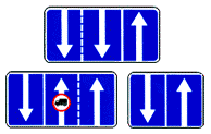 5.15.7 "Direction of traffic along the lanes."
If sign 5.15.7 shows a sign prohibiting the movement of any vehicles, then the movement of these vehicles in the corresponding lane is prohibited.
Signs 5.15.7 with the appropriate number of arrows can be used on roads with four or more lanes.
 5.15.8 "Number of lanes".
Indicates the number of lanes and lane modes. The driver is obliged to comply with the requirements of the signs marked on the arrows.
5.16 "Bus and (or) trolleybus stopping place."
5.17 "Tram stopping place."
5.18 "Taxi parking area."
5.19.1, 5.19.2 "Pedestrian crossing".
If there are no markings 1.14.1 or 1.14.2 at the crossing, sign 5.19.1 is installed to the right of the road on the near border of the crossing relative to approaching vehicles, and sign 5.19.2 is installed to the left of the road on the far border of the crossing.
5.20 "Artificial hump".
Indicates the boundaries of an artificial roughness. The sign is installed at the nearest boundary of the artificial hump relative to approaching vehicles.
5.21 "Residential area".
The territory in which the requirements of the Road Traffic Rules of the Russian Federation are in force, establishing the rules of traffic in a residential area.
5.22 "End of the residential area."
![]()
![]() 5.23.1, 5.23.2 "Beginning of a populated area."
5.23.1, 5.23.2 "Beginning of a populated area."
The beginning of a populated area in which the requirements of the Road Traffic Rules of the Russian Federation are in force, establishing the procedure for traffic in populated areas. ![]()
![]() 5.24.1, 5.24.2 "End of a populated area."
5.24.1, 5.24.2 "End of a populated area."
The place from which on a given road the requirements of the Road Traffic Rules of the Russian Federation, establishing the procedure for traffic in populated areas, cease to apply.
![]() 5.25 "The beginning of the settlement."
5.25 "The beginning of the settlement."
The beginning of a populated area in which the requirements of the Road Traffic Rules of the Russian Federation, which establish traffic rules in populated areas, do not apply on this road.
![]() 5.26 "End of a settlement."
5.26 "End of a settlement."
The end of a populated area in which the requirements of the Road Traffic Regulations of the Russian Federation, which establish traffic rules in populated areas, do not apply on this road.
5.27 "Zone with limited parking."
The place from which the territory (section of the road) begins where parking is prohibited.
5.28 "End of restricted parking zone."
5.29 "Regulated parking zone".
The place from which the territory (section of the road) begins, where parking is permitted and regulated with the help of signs and markings.
5.30 "End of regulated parking zone."
5.31 "Zone with maximum speed limit."
The place from which the territory (section of the road) begins where the maximum speed is limited.
5.32 "End of zone with maximum speed limit."
5.33 "Pedestrian zone".
The place from which the territory (section of the road) begins where only pedestrian traffic is allowed.
5.34 "End of the pedestrian zone."
5.35 "Zone with restrictions on the environmental class of motor vehicles."
Designates the place from which the territory (section of the road) begins where the movement of mechanical vehicles is prohibited: the environmental class of which, indicated in the registration documents for these vehicles, is lower than the environmental class indicated on the sign; the environmental class of which is not indicated in the registration documents for these vehicles.
5.36 "Zone with restrictions on the environmental class of trucks."
Designates the place from which the territory (section of the road) begins where the movement of trucks, tractors and self-propelled vehicles is prohibited: the environmental class of which, indicated in the registration documents for these vehicles, is lower than the environmental class indicated on the sign; the environmental class of which is not indicated in the registration documents for these vehicles.
5.37 "End of the zone with restrictions on the environmental class of motor vehicles."
5.38 "End of the zone with restrictions on the environmental class of trucks."
6. Information signs.
Information signs inform about the location of populated areas and other objects, as well as established or recommended traffic modes.
6.1 "General maximum speed limits".
General speed limits established by the Road Traffic Rules of the Russian Federation.
The speed at which it is recommended to drive on this section of the road. The sign's coverage area extends to the nearest intersection, and when sign 6.2 is used together with a warning sign, it is determined by the length of the dangerous area.
6.3.1 "Turning space". Turning left is prohibited.
6.3.2 "Turning area". Length of the turning area. Turning left is prohibited.
6.4 "Parking location".
6.5 "Emergency stop strip". Emergency stop strip on a steep descent.
6.6 "Underground pedestrian crossing".
6.7 "Overground pedestrian crossing".
6.8.1 - 6.8.3 "Deadlock". A road with no through passage.
 6.9.1 "Advance directions"
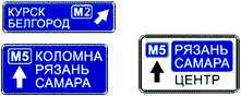 6.9.2 "Advance direction indicator".
Directions to the settlements and other objects indicated on the sign. Signs may contain images of the sign 6.14.1  , highway, airport and other pictograms. Sign 6.9.1 may contain images of other signs informing about traffic patterns. At the bottom of sign 6.9.1, the distance from the place where the sign is installed to the intersection or the beginning of the deceleration lane is indicated.
Sign 6.9.1 is also used to indicate a detour around sections of roads on which one of the prohibition signs 3.11 - 3.15 is installed.
6.9.3 "Traffic pattern".
The route of movement when certain maneuvers are prohibited at an intersection or permitted directions of movement at a complex intersection.
 6.10.1 "Direction indicator"
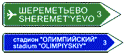 6.10.2 "Direction indicator".
Driving directions to route points. The signs may indicate the distance (km) to the objects indicated on them, as well as symbols of a highway, airport and other pictograms.
6.11 "Object name".
The name of an object other than a populated area (river, lake, pass, landmark, etc.).
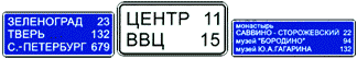 6.12 "Distance indicator".
Distance (km) to settlements located along the route.
6.13 "Kilometer sign". Distance (km) to the beginning or end of the road.
 6.14.1, 6.14.2 "Route number".
6.14.1 - number assigned to the road (route); 6.14.2 - number and direction of the road (route).
6.16 "Stop line".
The place where vehicles stop when there is a prohibiting traffic light signal (traffic controller).
6.17 "Detour diagram". Route to bypass a section of road temporarily closed to traffic.
Direction to bypass a section of road temporarily closed to traffic.
6.19.1, 6.19.2 "Preliminary indicator for changing lanes onto another carriageway."
The direction to bypass a section of the roadway closed to traffic on a road with a dividing strip or the direction of movement to return to the right roadway.
6.20.1, 6.20.2 "Emergency exit". Indicates the place in the tunnel where the emergency exit is located.
![]()
![]() 6.21.1, 6.21.2 "Direction of movement to the emergency exit." Indicates the direction to the emergency exit and the distance to it.
6.21.1, 6.21.2 "Direction of movement to the emergency exit." Indicates the direction to the emergency exit and the distance to it.
On signs 6.9.1, 6.9.2, 6.10.1 and 6.10.2 installed outside a populated area, a green or blue background means that traffic to the specified populated area or object will be carried out, respectively, along a motorway or other road. On signs 6.9.1, 6.9.2, 6.10.1 and 6.10.2 installed in a populated area, inserts with a green or blue background mean that movement to the specified populated area or object after leaving this populated area will be carried out accordingly according to motorway or other road; The white background of the sign means that the specified object is located in this locality.
7. Service marks.
Service signs inform about the location of the relevant facilities.
7.1 "Medical aid station".
At the beginning of the twentieth century, when automobile traffic was just emerging, there was a need to ensure road safety so that all drivers could unambiguously interpret the information they received. This is how standardized road signs appeared in 1909. With the growth of the automobile industry, the number of road signs regulating traffic also increased. And now there are more than 120 of them. For convenience, the signs are divided into categories.
1. Warning signs- placed on difficult sections of the road to increase driver vigilance. Signs in this category are made in the form of a triangle with a white background and a red border, or in the form of a rectangle with a white or red background.

2. Priority signs determine the sequence in which road users must pass controversial sections of the road, such as intersections. The signs of this group are made in different colors and differ in shape: you can find a triangle with a red border, a blue rectangle, and even a red heptagon.

3. Prohibition signs. As the name suggests, this category includes signs that prohibit any action. For example, prohibiting overtaking or using a sound signal. In most cases, these signs have a round shape, a white background, a red border, and in the middle there is an image of what the sign prohibits. Exceptions include a sign prohibiting entry (has a red background), a sign prohibiting stopping and parking (have a blue background), as well as signs lifting prohibitions (have a white background).

4. Mandatory signs indicate the permitted direction of movement, and also limit the minimum speed. These signs are also made in the form of a circle, but the symbols are depicted on a blue background. Again, there are some exceptions: signs intended for vehicles carrying dangerous goods are a rectangle with a white background.

5. Signs of special regulations combine the two previous groups of signs and are intended to indicate stops for route vehicles, roads with one-way or reverse traffic, etc. These signs are made in the shape of a rectangle with a white or blue background. The exception is the signs that indicate movement on the motorway (5.1-5.2), they are made in green.


6. Information signs. As the name suggests, these signs are for reference purposes and tell you about the names of objects, recommended speed limits and traffic patterns. The exception is signs 6.3.1 and 6.3.2, which allow a U-turn but prohibit a left turn.

7. Service marks. Like the previous category, signs are for reference purposes and indicate the location of certain structures on your route (hospitals, gas stations, campsites, etc.). The corresponding object is depicted in a white rectangle with a blue border.

In July 2017, sign 7.21 was added, which indicates that an electric vehicle can be charged at a gas station.

8. Additional information signs are made as white rectangular signs and most often regulate the boundaries of the action of the signs under which they hang. In some cases, for example when indicating a parking method, these signs can be used independently.

In July 2017, a new plate 8.25 was introduced, clarifying the environmental class of the car.

New road signs from July 1, 2018
On July 1, 2018, new environmental road signs 5.35 and 5.36 will be introduced. These signs can be supplemented by plate 8.23 “Photo and video recording”.
Sign 5.35 introduces a ban on the movement of vehicles whose environmental class is less than the number indicated on the sign.
Sign 5.36 introduces a ban on the movement of trucks, tractors and self-propelled vehicles with an environmental class less than the number indicated on the sign.
These signs will not apply to vehicles of the armed forces, police, rescuers, ambulances, emergency gas service and mail.
Plate 8.25 will also be introduced, the meaning of which depends on the sign with which it is used.
Punishment for failure to comply with road sign requirements 2019
Ignoring road signs is punishable by either a fine or deprivation of rights for a certain period. Often, for the same violation, the Code of Administrative Offenses prescribes both types of punishments; in this case, the choice of punishment will be up to the traffic police officer. The minimum fine is 500 rubles (assigned, for example, for driving through a stop sign without stopping). The maximum fine is 5,000 rubles; it is imposed, for example, for driving in the wrong direction on a one-way road. The same violation can be punishable by deprivation of rights for 4-6 months. In case of repeated administrative violation, the rights will be withdrawn for a year.
If you do not want to lose your driver's license, you must definitely learn the meaning of road signs. When driving experience is short, road signs are difficult to remember, and while driving, noticing and remembering what this or that sign means, and even more so the combination of signs, is even more problematic. Do not despair! The main thing in this difficult task is practice. Moreover, you need to train not only while driving your car, but also when you are traveling on public transport or just walking around the city. We saw the sign, remembered what it meant, and decided how to act in this situation. To reinforce the material, you can also watch the training video.


